RELEASE
June 16, 2025 (TOKYO, Japan)Release
OPTiM Corporation
(TSE:3694)
OPTiM Launches Geo Scan Supreme for OPTiM Geo Scan Smartphone Survey App, Achieving Millimeter-Level Measurement Accuracy
Compliant with MLIT Guidelines for Pavement Construction Using 3D Measurement Technology
OPTiM Corporation (hereinafter OPTiM) announces the launch of Geo Scan Supreme in July 2025, a new feature for its smartphone surveying app OPTiM Geo Scan (hereinafter Geo Scan) that enables the acquisition of point cloud data with millimeter-level accuracy (hereinafter millimeter precision). Geo Scan Supreme complies with※1 the pavement construction requirements specified in the Guidelines for Construction Management Using 3D Measurement Technology※2 established by the Ministry of Land, Infrastructure, Transport and Tourism (MLIT). This marks the world's first※3 smartphone surveying app that enables anyone to easily acquire point cloud data with millimeter precision necessary for construction management.
■Background
In MLIT's i-Construction initiative, the use of ICT is expanding beyond earthwork to include pavement and structural construction projects that require high-precision surveying. However, at construction sites requiring millimeter-precision measurements for pavement and structural work, while terrestrial laser scanners and other expensive equipment have been used, their widespread adoption has been hindered by the following challenges:
Cost-related challenges:
- Requires substantial initial investment (tens of millions of yen)
Operational challenges:
- Requires specialized knowledge and skills
- Can only be operated by limited number of technical experts
Consequently, there has been a growing demand for a new solution that maintains high measurement accuracy while being cost-effective and easy to implement and operate, regardless of construction type or site scale.
■Overview of Geo Scan Supreme
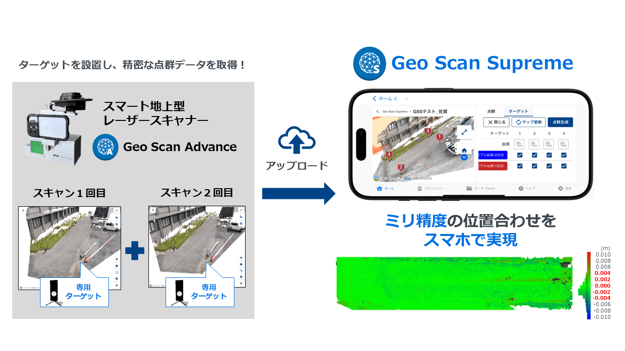
Geo Scan Supreme enables anyone to easily acquire millimeter-precision point cloud data required for construction management using a smartphone. This solution addresses both cost and operational challenges that have hindered ICT adoption in the construction industry.
- Cost Benefits: Significantly Reduces Initial Investment
- Eliminates the need for expensive terrestrial laser scanners
- Generated point cloud data is only several MB in size, eliminating the need for expensive specialized software and high-specification PCs
- Operational Benefits: Enables High-Precision Surveying and Data Processing on Smartphone Without Specialized Technicians
- Achieves intuitive and simple operation through smartphone app, allowing anyone without specialized knowledge to perform tasks traditionally requiring highly skilled technicians
- Automatically recognizes Geo Scan Supreme dedicated targets within point clouds through the smartphone app, enabling automatic alignment and high-precision point cloud generation
- Enables real-time verification of measurement results on-site through smartphone-based operation
■Measurement Accuracy and Application Areas of Geo Scan Supreme
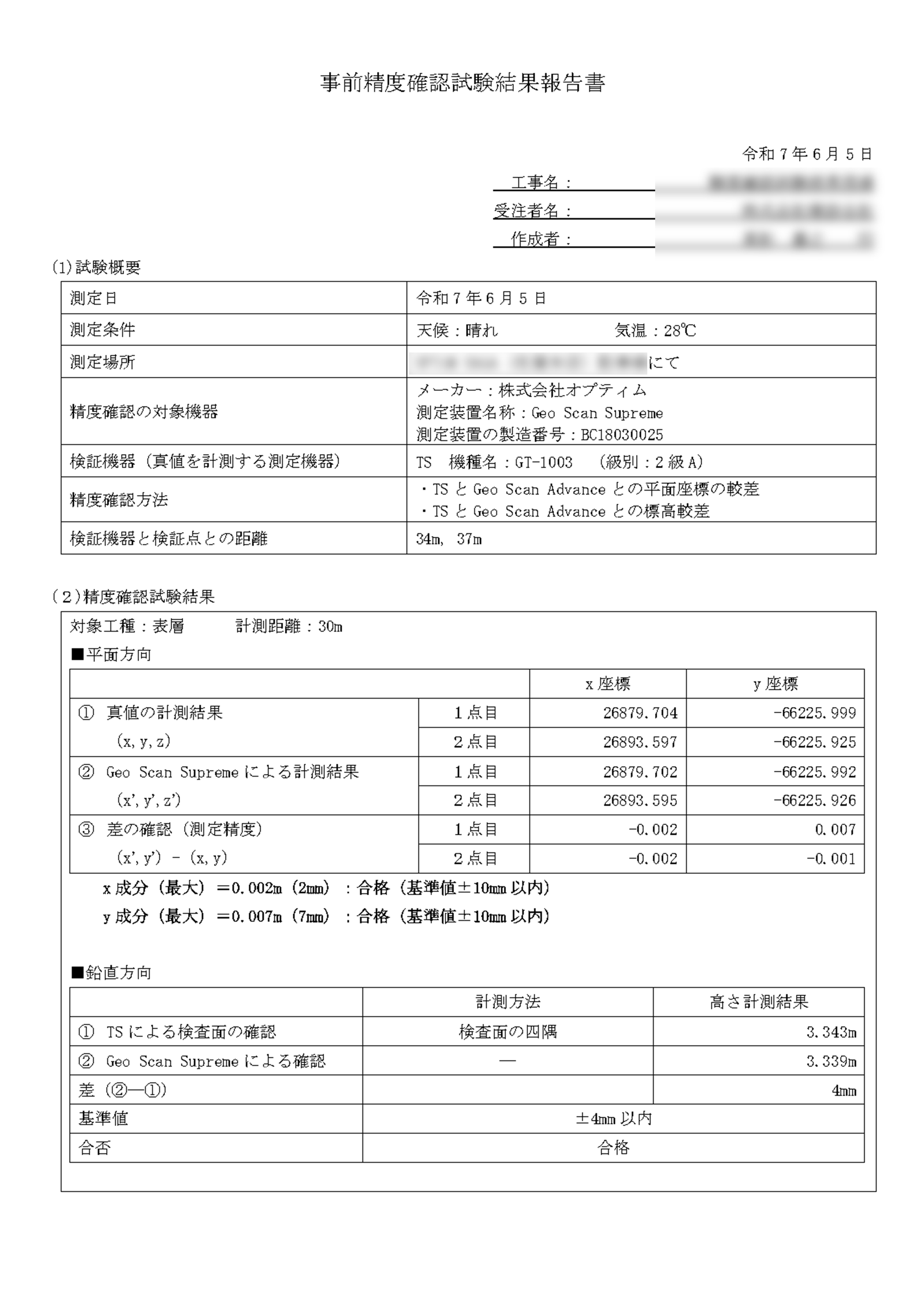
Geo Scan Supreme has passed the accuracy verification tests for pavement construction as specified in the MLIT Guidelines for Construction Management Using 3D Measurement Technology, as detailed below. This enables its use in construction management of pavement works requiring millimeter-precision measurements.
◆Accuracy Verification Test Results Report
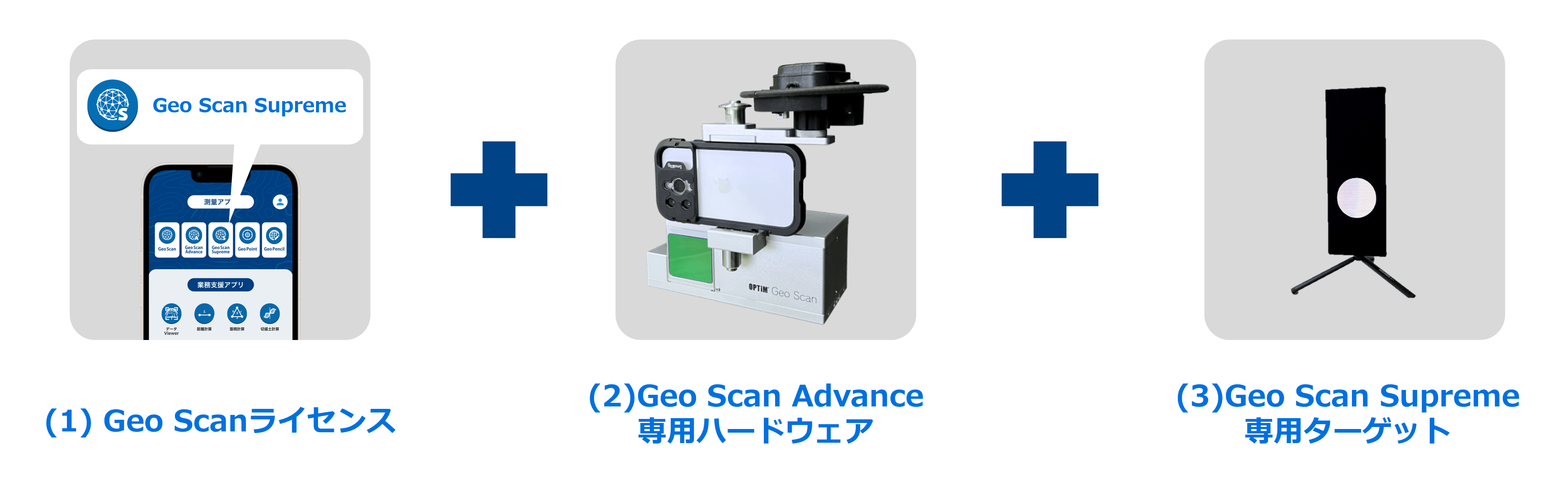
■Usage Requirements for Geo Scan Supreme
All three of the following conditions must be met:
- (1) Active annual license for Geo Scan
- (2) Purchase of Geo Scan Advance dedicated hardware
- (3) Purchase of Geo Scan Supreme dedicated targets
■Details and Information on Geo Scan Supreme
Please contact us using the form below:
https://www.optim.co.jp/contact/optim-geo-scan?purpose=demo
※Please enter Request Geo Scan Supreme Details in the field Intended use of Geo Scan/Details of planned work site (free description).
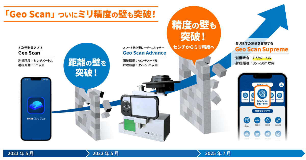
■Evolution of Geo Scan
The smartphone surveying app Geo Scan was launched in May 2021 and has since contributed to ICT adoption in the construction industry as a professional surveying app offering high measurement accuracy and compliance with MLIT guidelines for earthwork construction management.
In May 2023, we introduced Geo Scan Advance, which extended the point cloud capture range to 35-50m, enabling measurements of elevated areas and wide spaces that were difficult to measure with smartphone LiDAR functionality alone. This accelerated ICT adoption across various sites, including large-scale terrain surveys and earthwork inspections. However, we received numerous requests from users for capabilities to handle millimeter-precision inspections of structures and pavements.
In response to these industry needs, we have developed Geo Scan Supreme, which achieves the millimeter-precision previously unattainable with conventional products, enabling expansion into areas requiring higher measurement accuracy, such as road pavement construction.
■Information for Those Interested in Geo Scan
We offer the following information and events:
- For Demo Requests, Media Inquiries, and Quotations:
https://www.optim.co.jp/contact/optim-geo-scan?purpose=demo - Geo Scan Trial Sessions:
https://www.optim.co.jp/construction/optim-geo-scan/lp/trial/ - Geo Scan Web Seminars:
https://www.optim.co.jp/construction/optim-geo-scan/seminar/ - Download Detailed and Helpful Materials about Geo Scan:
https://www.optim.co.jp/construction/optim-geo-scan/download/ - For More Information about Geo Scan:
https://www.optim.co.jp/construction/optim-geo-scan/
| ※1 | According to OPTiM research as of June 11, 2025. Verification was conducted in accordance with the surface management guidelines for pavement construction using Terrestrial Laser Scanner (TLS) as specified in MLIT Guidelines for Construction Management Using 3D Measurement Technology (Draft), March 2025 Edition, confirming compliance with these guidelines. (Specifically, compliance was confirmed with measurement performance and accuracy management requirements in Appendix 2, Part 2 Pavement Construction, Chapter 1 Surface Management, Section 1.1 Terrestrial Laser Scanner (TLS)) |
| ※2 | A compilation of construction management standards based on 3D measurement technology and dimensional specifications for ICT construction projects. (MLIT Guidelines for Construction Management Using 3D Measurement Technology (Draft), March 2025 Edition: https://www.mlit.go.jp/tec/constplan/content/001880735.pdf) |
| ※3 | According to OPTiM research as of June 11, 2025. As a smartphone surveying app capable of meeting millimeter-precision standards required by MLIT Guidelines for Construction Management Using 3D Measurement Technology (Draft), March 2025 Edition. |
■About OPTiM Corporation
OPTiM is a leader in internet-based services that improve its clients’ interactions with technology in all aspects of everyday life. Its solutions provide comprehensive IoT management and multifunctional remote communication. Its business partners include NTT East, NTT West, NTT DOCOMO, OTSUKA, SoftBank, Canon Marketing Japan, Panasonic Solution Technology, Ricoh Japan, KDDI and Fujifilm Business Innovation Japan. Based in Tokyo, Japan, its corporate motto is, "We make the net as simple as breathing.".
【Copyright / Trademark】
※ The company names and product names mentioned are registered trademarks and trademarks of their respective companies.
※ The information presented in this press release is subject to change without notice.
■Media Contacts
Public Relations
press@optim.co.jp